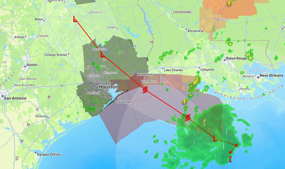
HOUSTON A tropical depression in the northern Gulf is moving toward the Upper Texas Coast and is expected to strengthen before reaching land. The National Hurricane Center said Tropical Depression Five had maximum sustained winds of 35 mph at 4 p.m. Monday and was about 185 miles southeast of Port Arthur. It was moving west-northwest at about 6 mph.
Forecasters expect the system to become a tropical storm Monday evening. If that happens, it will be named Tropical Storm Edouard. The current forecast takes the center toward the northwestern Gulf Coast on Tuesday, followed by movement inland across Southeast Texas Tuesday night. The National Hurricane Center is not currently forecasting the system to become a hurricane.
A Tropical Storm Warning is in effect from Port Bolivar, Texas, eastward into southwestern Louisiana. The warning means tropical storm conditions are expected somewhere within that area. The National Weather Service said Chambers County could see sustained winds of 20 to 30 mph, with gusts reaching around 40 mph in some locations.
Heavy rain may become the larger problem for many Texans. The National Hurricane Center expects 3 to 6 inches of rain across parts of the Upper Texas Coast and farther inland into east-central Texas. Isolated locations could receive as much as 9 inches. Forecasters warn that the rain could cause flash flooding, especially in cities and low-lying areas. River flooding is also possible.
The National Weather Service has issued a Flood Watch from early Tuesday through Wednesday morning for Houston and several surrounding areas. The watch includes portions of Harris County and Galveston County, along with Montgomery County and areas east of Houston. Forecasters say repeated heavy downpours could overwhelm drainage systems and flood streets.
Coastal communities also face a risk from rising water. A Storm Surge Watch has been issued from High Island, Texas, into southwestern Louisiana. The National Hurricane Center said water could rise about 1 to 3 feet above normally dry ground in some coastal areas if the storm surge arrives near high tide. The highest water is expected close to where the center reaches the coast and to its east.
The Houston area may avoid the strongest winds if the storm follows its current path, but its large rain shield could still create problems across the metro area. Areas closer to Beaumont and the Texas-Louisiana border have a greater chance of stronger wind. Galveston and communities near the coast could see worsening conditions Tuesday as the storm approaches.
Texas officials began preparing before the system became a tropical depression. Gov. Greg Abbott said Sunday that state officials were monitoring the developing storm and coordinating with electricity providers. CenterPoint Energy also activated its Emergency Operations Center and began positioning crews in case the storm causes power outages around Houston.
The storm developed quickly. On Sunday morning, forecasters gave the Gulf disturbance only a 30% chance of becoming a tropical system. By Monday afternoon, Hurricane Hunter aircraft found enough circulation for the National Hurricane Center to officially classify it as Tropical Depression Five. That quick development is one reason officials are asking residents along the coast to continue watching forecasts closely.
The greatest effects are expected from Tuesday into early Wednesday. Residents in flood-prone areas should watch local warnings and avoid driving onto flooded roads. The storm is expected to weaken after moving inland, but its rain could continue affecting parts of East Texas even after the center moves away from the coast.