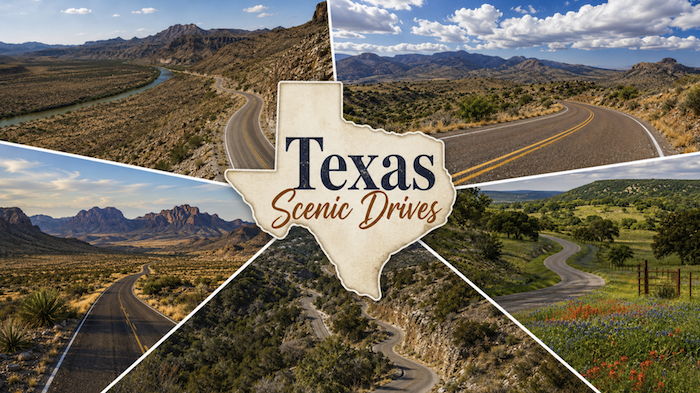
Texas is too large and varied to be understood from an interstate. To really see the state, drivers have to leave the high-speed corridors and follow the roads that twist through desert mountains, limestone canyons, river valleys and Hill Country ranchland.

Five of the best routes are FM 170, also known as River Road; the Davis Mountains Scenic Loop; Ross Maxwell Scenic Drive in Big Bend National Park; Willow City Loop near Fredericksburg; and the Twisted Sisters in the Hill Country. Each offers a different version of Texas, from the borderlands of the Rio Grande to the winding roads west of San Antonio.
All five routes show a different Texas — desert, mountain, canyon, river and ranchland — and all reward drivers who slow down, stop often and treat the road as the destination. Here are our Top 5 picks listed in particular order.
1. FM 170 / River Road
Location: Terlingua, Lajitas, Big Bend Ranch State Park and Presidio
Distance: About 50 to 66 miles, depending on whether the drive is measured from Lajitas or Terlingua to Presidio
Road type: Paved two-lane state farm-to-market road
General condition: Paved and usually passable by regular passenger vehicles, but remote, curvy, steep in places and without many services.
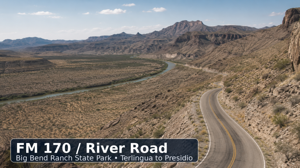
FM 170 may be the most dramatic public road in Texas. The route follows the Rio Grande through the Big Bend borderlands, passing between Lajitas and Presidio with Big Bend Ranch State Park on one side and Mexico across the river on the other.
The road is famous for long desert views, sharp curves, river overlooks and steep climbs. One of its best-known features is “Big Hill,” often described as one of the steepest paved highway grades in Texas. The climb rewards drivers with a sweeping view of the Rio Grande corridor, desert ridges and the rugged Chihuahuan Desert landscape.
The drive passes near the Barton Warnock Visitor Center, which is a good stop for maps, park information and exhibits about the desert environment. Lajitas offers lodging, a golf resort and the quirky local tradition of a goat “mayor.” Terlingua and the nearby ghost town area provide restaurants, bars, lodging and roadside character before or after the drive.
Interesting places to eat or stop include the Starlight Theatre in Terlingua, Espresso y Poco Mas, DB’s Rustic Iron BBQ, the Lajitas General Store and options inside Lajitas Golf Resort. In Presidio, travelers can find fuel, border-town restaurants and access toward Marfa or the Fort Leaton State Historic Site.
The road itself is paved, but it should not be treated like a suburban highway. There are curves, steep grades, low-water areas, limited cell service and long distances between services. Drivers should carry water, fuel up before leaving, avoid speeding and use extra caution in rain or darkness.
2. Davis Mountains Scenic Loop
Location: Fort Davis, Texas 118 and Texas 166
Distance: About 75 miles
Road type: Paved two-lane mountain highway loop
General condition: Paved and generally suitable for normal passenger vehicles, with elevation changes, curves and remote stretches.
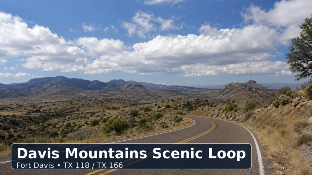
The Davis Mountains Scenic Loop shows a cooler, higher and more alpine-feeling side of Texas. Beginning and ending near Fort Davis, the loop follows Texas 118 and Texas 166 through high desert, volcanic mountains, ranchland and some of the loftiest public roads in the state.
Texas Parks and Wildlife lists the Scenic Loop Drive as a 75-mile loop through the Davis Mountains beginning and ending in Fort Davis. The route also gives travelers access to some of the region’s best-known attractions, including Davis Mountains State Park, Fort Davis National Historic Site, the Chihuahuan Desert Nature Center and McDonald Observatory.
The landscape changes quickly along the loop. Drivers pass grasslands, rocky slopes, mountain ridges, desert plants and open sky. The elevation makes the route feel very different from most of Texas, especially in the morning or near sunset.
The McDonald Observatory is one of the most important stops along the route. It offers visitor programs and is famous for West Texas stargazing. Fort Davis National Historic Site gives travelers a look at frontier military history, while Davis Mountains State Park offers hiking, camping and the historic Indian Lodge.
In Fort Davis, restaurants and small businesses include the Fort Davis Drug Store, Stone Village Market, Blue Mountain Bistro and local lodging around the historic town square. Nearby Alpine and Marfa offer additional restaurants, galleries and hotels for travelers making a longer West Texas trip.
The road is paved, but drivers should expect curves, hills, elevation changes and limited services once they leave Fort Davis. Wildlife, loose gravel on shoulders and changing weather can be hazards, especially at dusk.
3. Ross Maxwell Scenic Drive
Location: Big Bend National Park
Distance: About 30 miles one way
Road type: Paved national park road
General condition: Paved and suitable for normal vehicles, though closures can occur after flooding or storms.
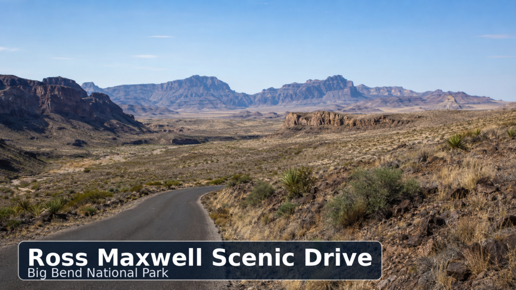
Ross Maxwell Scenic Drive is one of the best ways to see Big Bend National Park without taking a long backcountry road. The National Park Service describes it as a 30-mile scenic drive leading to the Castolon Historic District and Santa Elena Canyon while showcasing the park’s historic and geologic features.
The route begins in the central part of the park and drops toward the Rio Grande. Along the way, travelers pass overlooks, desert washes, volcanic formations, old ranch sites and views of the Chisos Mountains. Notable stops include Sotol Vista, Mule Ears Overlook, Tuff Canyon, Sam Nail Ranch, Homer Wilson Ranch, Castolon and Santa Elena Canyon.
Santa Elena Canyon is the scenic anchor at the end of the drive. The canyon walls rise dramatically above the Rio Grande, making it one of the most photographed places in Big Bend. Castolon provides history, restrooms and a small visitor area, though services can vary.
There are no full-service restaurants directly on Ross Maxwell Scenic Drive. Travelers usually eat before or after the drive in the Chisos Basin, at park lodging or outside the park in Study Butte, Terlingua or Marathon. Terlingua offers several well-known restaurants and lodging options, while the Chisos Mountains Lodge area is the main in-park service hub.
The road is paved and accessible to standard vehicles, but visitors should check current National Park Service road conditions before going, especially after rain. Flash flooding, washouts and temporary closures can affect parts of Big Bend. Drivers should carry water and not rely on cell service.
4. Willow City Loop
Location: Northeast of Fredericksburg, Gillespie County
Distance: About 13 miles for the loop itself; about 35 to 40 miles round trip from Fredericksburg, depending on route
Road type: Narrow paved rural ranch road
General condition: Paved but narrow, with low-water crossings, private property along the route and heavy traffic during wildflower season.
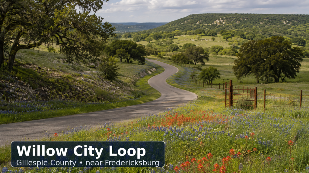
Willow City Loop is one of the most famous spring drives in Texas. The route is located northeast of Fredericksburg and winds through Hill Country ranchland, rocky hills, creek beds and wildflower fields. It is especially popular during bluebonnet season, but the drive is scenic even outside the spring bloom.
Fredericksburg visitor guides describe the loop as a private ranch road that winds about 13 miles through rugged Hill Country before reconnecting with Texas 16. Texas Time Travel directs travelers from Fredericksburg north on State Route 16, east on Ranch Road 1323 and then onto Willow City Loop.
The landscape is classic Hill Country: limestone hills, oak trees, cattle guards, ranch fences, creek crossings and seasonal flowers. In good years, the spring bloom can bring bluebonnets, Indian paintbrush and other wildflowers across the hillsides.
Because much of the land is private, travelers should not trespass, block gates, climb fences or stop in unsafe areas. The road can become crowded in peak wildflower season, especially on weekends.
The best restaurant and business options are in Fredericksburg before or after the drive. Notable stops include Eaker Barbecue, Otto’s German Bistro, Altdorf Biergarten, Cabernet Grill, Das Peach Haus, Wildseed Farms and the shops along Main Street. Nearby attractions include Enchanted Rock State Natural Area, Luckenbach, the National Museum of the Pacific War and Lyndon B. Johnson sites around Stonewall.
The road is paved but narrow. Drivers should expect slow speeds, curves, low-water crossings, pedestrians taking photos and limited shoulders.
5. The Twisted Sisters
Location: Hill Country near Leakey, Camp Wood, Medina, Barksdale and Vanderpool
Distance: About 100 miles for the classic loop; some versions run closer to 100 to 120 miles
Road type: Paved ranch roads and state roads, mainly RR 335, RR 336 and RR 337
General condition: Paved but challenging, with sharp curves, steep hills, river crossings, blind turns and limited guardrails in places.
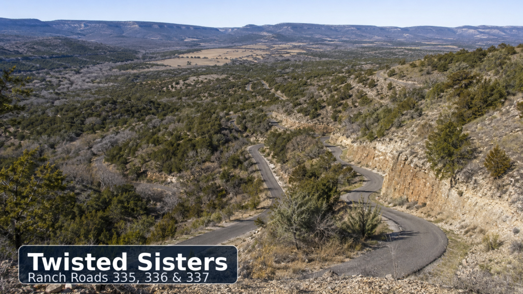
The Twisted Sisters are three Hill Country ranch roads — RR 335, RR 336 and RR 337 — that form one of the most famous driving and motorcycle routes in Texas. The route is known for tight curves, steep climbs, canyon views, river valleys and a more rugged version of the Hill Country than the wineries and shops around Fredericksburg.
Rider and road-trip guides commonly describe the full route as roughly 100 miles, with some versions reaching 100 to 120 miles depending on the starting point and connectors. The route is especially popular with motorcyclists, but it is also a memorable drive for cars, trucks and sports-car enthusiasts.
The scenery includes limestone hills, open ranchland, the Frio River, the Nueces River, the Sabinal River, rocky ridges and small towns. Leakey is the most common base for the loop, while Camp Wood, Barksdale, Medina and Vanderpool provide other access points.
Interesting stops include the Frio Canyon Motorcycle Stop in Leakey, Bent Rim Grill, the Leakey Mercantile, Garner State Park, Lost Maples State Natural Area, the Lone Star Motorcycle Museum near Vanderpool and small-town restaurants in Camp Wood and Medina. The area is also popular for cabin rentals, river trips and fall foliage at Lost Maples.
This is the most technically demanding drive on the list. The pavement is generally suitable for normal vehicles, but the route has sharp curves, sudden elevation changes, limited shoulders, wildlife, motorcycles, bicycles and occasional loose gravel. Drivers should stay within their lane, avoid distractions and leave the route to daylight hours if unfamiliar with the road.
Choosing the Right Drive
For the most dramatic scenery, FM 170 is the top choice. For mountain views and a cooler West Texas feel, the Davis Mountains Scenic Loop is hard to beat. For a classic Big Bend experience inside the national park, Ross Maxwell Scenic Drive is the easiest recommendation. For spring wildflowers, Willow City Loop is the iconic Hill Country drive. For curves and driving excitement, the Twisted Sisters are the most challenging.
Remember,… all five routes show a different Texas — desert, mountain, canyon, river and ranchland — and all reward drivers who slow down, stop often and treat the road as the destination.